
O1.M1.04. Reinventing the grid: the thin line between relevance and oblivion – Case study: Jimbolia in the new economic context
Free
About this course
Chapter 1. Theoretical principles of territorial resilience and the main driving factors for growth, stagnation or shrinkage
Teaching method: lecture – theoretical approach
Duration: 20 min
The aim of this class is to generate a debate on whether the strict confines of the grid and the urban structures that it generates can maintain their relevance under the unprecedented strong economic pressures of the present-day context. Having thrived and continuously adapted throughout centuries, some colonial settlements find it difficult to accommodate the economical growth, while also respecting the strict rules of colonial urban development.
This chapter therefore concentrates on introducing students to the main effects of the design according to the scenarios of territorial increase, decrease or stagnation[1], related to the main challenge of achieving resilience.
The concept of territorial resilience[2] refers to the ability of a territory (and its settlements) to continuously adapt to the ever changing economic, social and environmental context, while also maintaining the balance between urban, rural and natural environments[3].
From the point of view of the factors that influence the resilience of a territory, the specialized literature refers to four agents:
-
- the development of the economic sectors, other than the primary one;
- the technological evolution;
- the quality of life;
- the security and safety of the population.
Figure 1.1: The factors that influence the resilience of a territory (schematic representation)
From the authors, after Echave, C. (2022)
Thus, the first approach involves structural changes brought about by the transition from the primary to the secondary or even tertiary sector of the economy, which refer to the transition from a production model (influenced by climate characteristics) to one that can be determined and influenced regionally.
Secondly, technological changes involve facilitating previously impossible connections, helping territories to develop through disruptive procedures. Such changes may relate to the ability to communicate and exchange data over long distances at higher speeds, to the possibility of ensuring physical access to large-scale markets, or to the ability to borrow from nature and efficiently process specific resources.
Moving on, the quality of life is the main determinant for demographic change; as such, the whole package of elements that contribute to a higher life quality (from higher incomes to qualitative products, health services and education) takes center stage.
Last but not least, security and safety refer to the possibility of armed conflicts. Although they are rather specific to periods that we have long considered obsolete, they become important factors especially when such a hypothesis is completely ruled out and becomes a surprise. The military conflict involves immediate disruptions and massive aid for reconstruction, sending a territory to the minimum level of possibilities for recovery.
Of course, the four factors presented above are not the only valid explanations, but they are the primary categories that are the easiest to understand.
Chapter 2. Territories’ performance in history – a brief introduction to territorial performance in relation to various economic and political influences
Teaching method: lecture – exemplification, case study
Duration: 50 min
The main purpose of this chapter is to introduce objective methods by which students can understand the prospective evolution of a territory, helping them to acquire design skills in relation to a context that is stagnant, declining or increasing. Especially relevant for major infrastructure projects, single public objectives and repetitive ones (such as national / cross-border facilities and connections), this class offers the possibility of a realistic approach, adapted to the context and economic realities of a particular site.
This chapter therefore concentrates on understanding the key features of public infrastructure projects and the impact they may have on territorial challenges.
The performance of the territories[4] could be analyzed, throughout history, from three distinct hypostases:
-
- the capacity of defense (military performance);
- the ability to develop a sustainable economy (economic and productive capacity);
- the possibility to ensure a minimum level of life quality for its inhabitants (on the socio-cultural level).

Figure 2.1: The criteria that allow for the evaluation of a territory’s performance throughout history (schematic representation)
From the authors
Each of these areas can be found in various initiatives, programs or strategies, implemented by the political power of the times. Thus, the administrative capacity, as a manifestation within the legal limits of the political will, becomes the fourth indicator of the performance of a certain territory.
A territory’s capacity of defense refers to both physical features of settlements (be it natural or man-made), as well as specific administrative measures, regarding the response in case of armed conflict.
Referencing the situation of the historical region of Banat, the natural characteristics of this area, which spreads on open fields, do not offer shelter or protection in the face of danger. At the same time, the massive deforestation and drainage of marshlands, initiated by the Hapsburgs in the 18th century and continued throughout the 19th century by the Austro-Hungarian administration, enhances visibility across the territory, making it difficult for potential enemies to orchestrate a surprise attack.
At the same time, the settlements’ cartesian conformation, developed on a geometrical street network, allows for an easily controllable urban structure, where intruders are rapidly spotted and isolated.
However, the settlements themselves are unlikely to ever experience an attack from outside, given the larger defense system of the region, which gravitates around the powerful citadel of Timișoara, rebuilt by the Hapsburgs in the early 18th century[5].
Moving on, in regard to the capacity of a territory to develop a sustainable economy, there are a number of factors that must be taken into consideration. First, there is the issue of resources – whether they exist or not, as well as how (and by whom) they are exploited. Secondly, infrastructure – both in terms of accessibility, as well as the network of production facilities – is also important. Finally, the relevance of the economic activities must also be taken into consideration – not only from the point of view of the realities of the market economies, but also from the perspective of social and environmental desideratum.
As for the historical region of Banat, the whole purpose for which it was colonized with multi-ethnic population during the 18th and 19th century was precisely to exploit the natural resources found here, as well as to generate economic growth in an area that is favorable to agriculture, as well as to industrial developments.
Thirdly, the issue of life quality within communities refers to the well-being of individuals, as well as of the society as a whole. As such, it is reflected in a series of minimal requirements regarding infrastructure (for both mobility and utilities), accessibility to public facilities, green areas and other public spaces, as well as living conditions provided by the housing units themselves.
The colonial settlements developed within the Banat region by the Hapsburg administration pay a great deal of attention to providing their inhabitants with both the facilities required for a qualitative day-to-day life, as well as with decent living conditions. As such, the Habsburg administration had strict rules in place, regarding both the public functions that needed to be developed in every settlement, as well as the conformation, building materials and techniques that should be utilized for building houses[6].
At the same time, the conformation of public spaces – with large streets, organized around a main public square, also ensure an extensive network of public areas, with clear delimitations between these and the private properties themselves.
Finally, the performance of the historical region of Banat has been enhanced by coherent administrative programs throughout the 18th, 19th and early 20th centuries[7] – starting with the Hapsburg Empire, continuing with Austro-Hungarian administration and – following the First World War – the governments of the three newly-emerged countries among which this region was split (Hungary, Yugoslavia and Romania).
However, the communist administrations, which came to power following the Second World War, deepened the differences that were already starting to show between these three countries, creating disruptions in both the structure of the society, as well as in the continuity of infrastructure works. As such, although these governments did develop some impressive projects (the extension of the drainage canals or that of the public roads’ network into the territory), which followed the patterns of the land, these would always stop at the border.
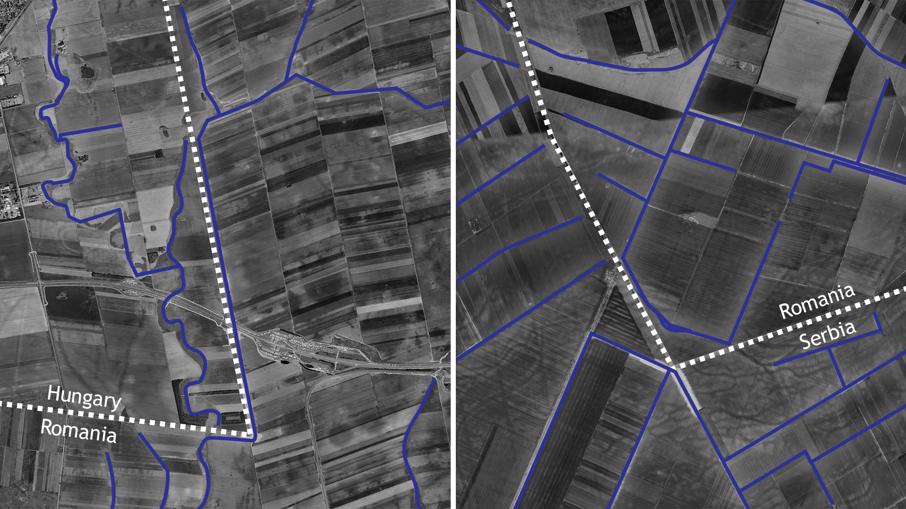
Figure 2.2: The network of drainage canals, developed within the historical region of Banat by the communist administrations in neighboring countries
Retrieved on Google Earth background
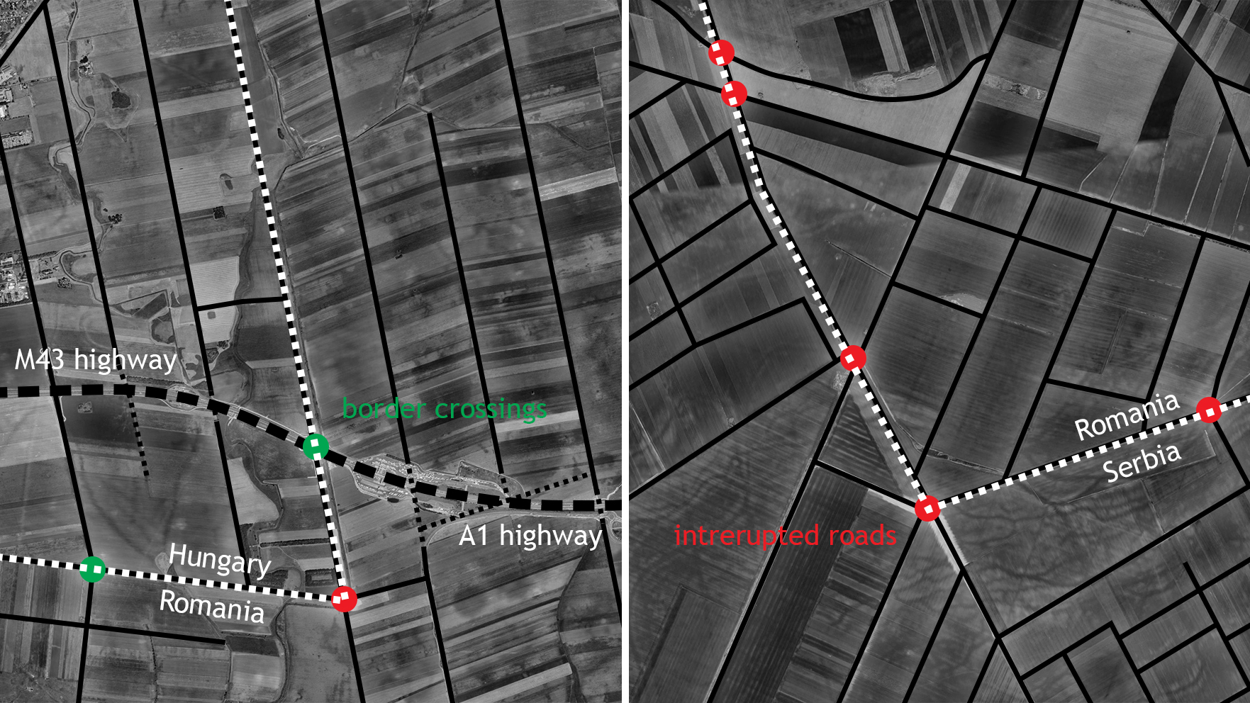
Figure 2.3: Disruptions within the public roads’ network during communist administrations in neighboring countries
Retrieved on Google Earth background
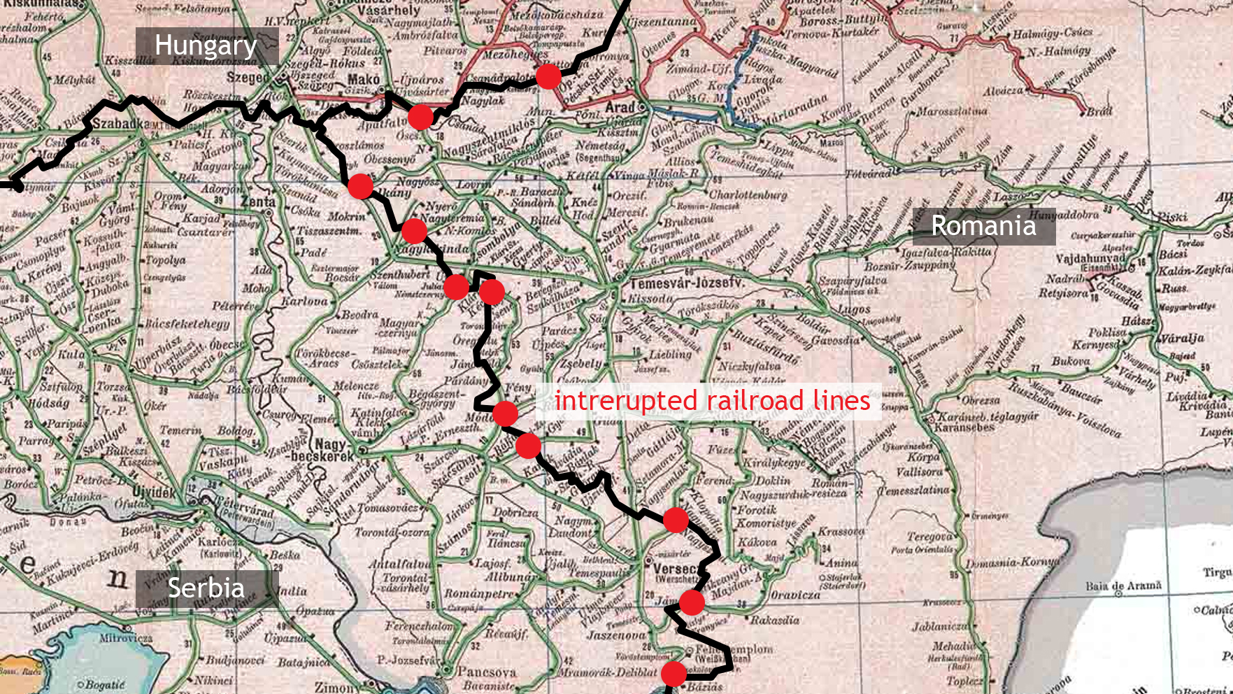
Figure 2.4: Disruptions within the railroad network during communist administrations in neighboring countries
Retrieved on Artaria’s Eisenbahnkarte background
Chapter 3. The colonial city of Jimbolia: current situation
Teaching method: lecture – exemplification, case study
Duration: 20 min
The following chapter concentrates on understanding the impact of project implementation and the effects produced, depending on the different scenarios a territory may go through.
These principles are analyzed in relation to the current situation of the town of Jimbolia, from the perspective of present-day realities of both economic and social nature.
Jimbolia overlaps a series of urban interventions, carried out over time to serve specific purposes, defined in the immediate term, especially economic. Thus, development patterns follow technological evolution, access to infrastructure or the discovery of raw materials useful for the regional economy, to generate what we now see as an urban settlement, with particular, prominent, refined elements with a much greater relevance than the locality itself. In this overlap of historical stages, the contemporary stage continues only previous processes.
However, not all the public projects currently under development or already implemented in Jimbolia adhere to the characteristics of the urban fabric. For instance, the modernization and rehabilitation of the Civic Center proposes a landscape intervention along Jimbolia’s main axis, thus transforming what was traditionally the main activity corridor of the town into an urban green promenade.
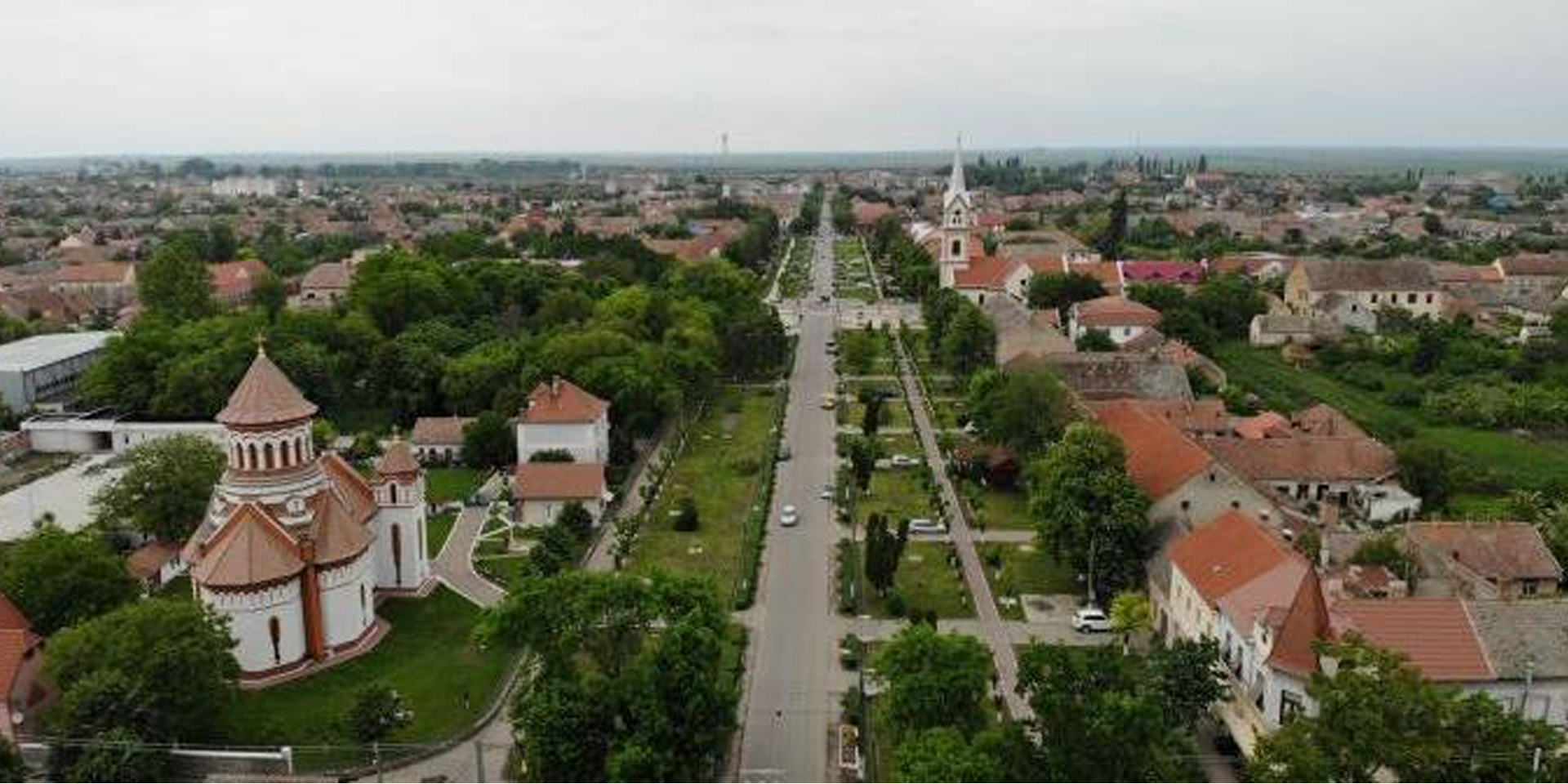
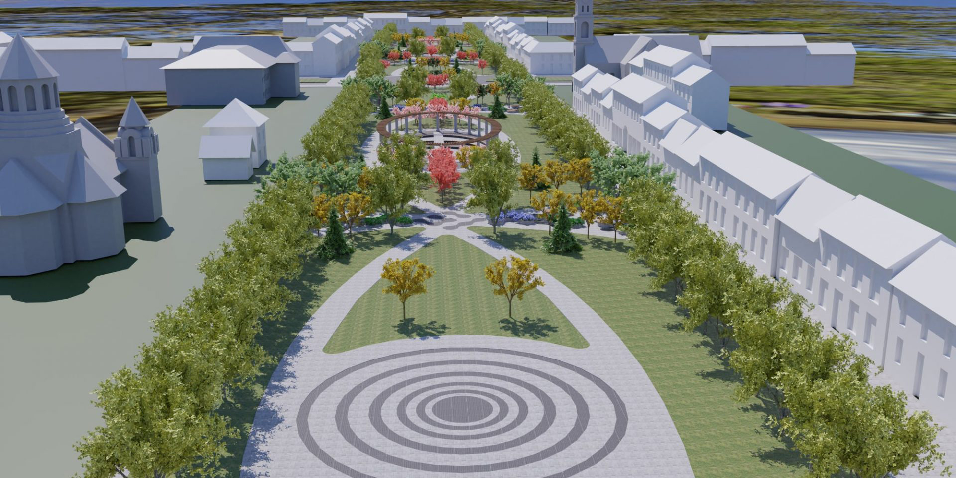
Figure 3.1: Modernization and rehabilitation of Jimbolia’s Civic Center. Current situation (Figure 3.1a) vs. proposal (Figure 3.1b)
Retrieved from Jimbolia Municipality
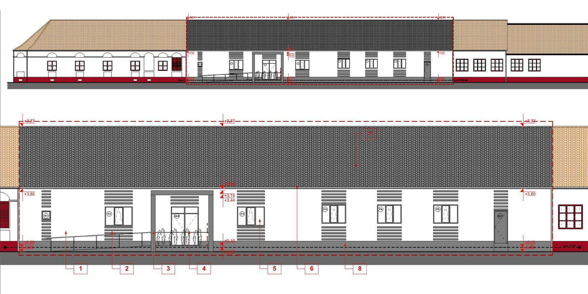
Figure 3.2: Proposal for Jimbolia’s new social canteen
Retrieved from Jimbolia Municipality
Finally, the rehabilitation, modernization and endowment of the Technological Highschool from Jimbolia provides the extension of the old building through a new pavilion, situated on the rear side of the plot, which contradicts both the rules regarding the terrain occupancy, as well as the urban silhouette (rising high above the other buildings and adopting a post-modern aesthetics).
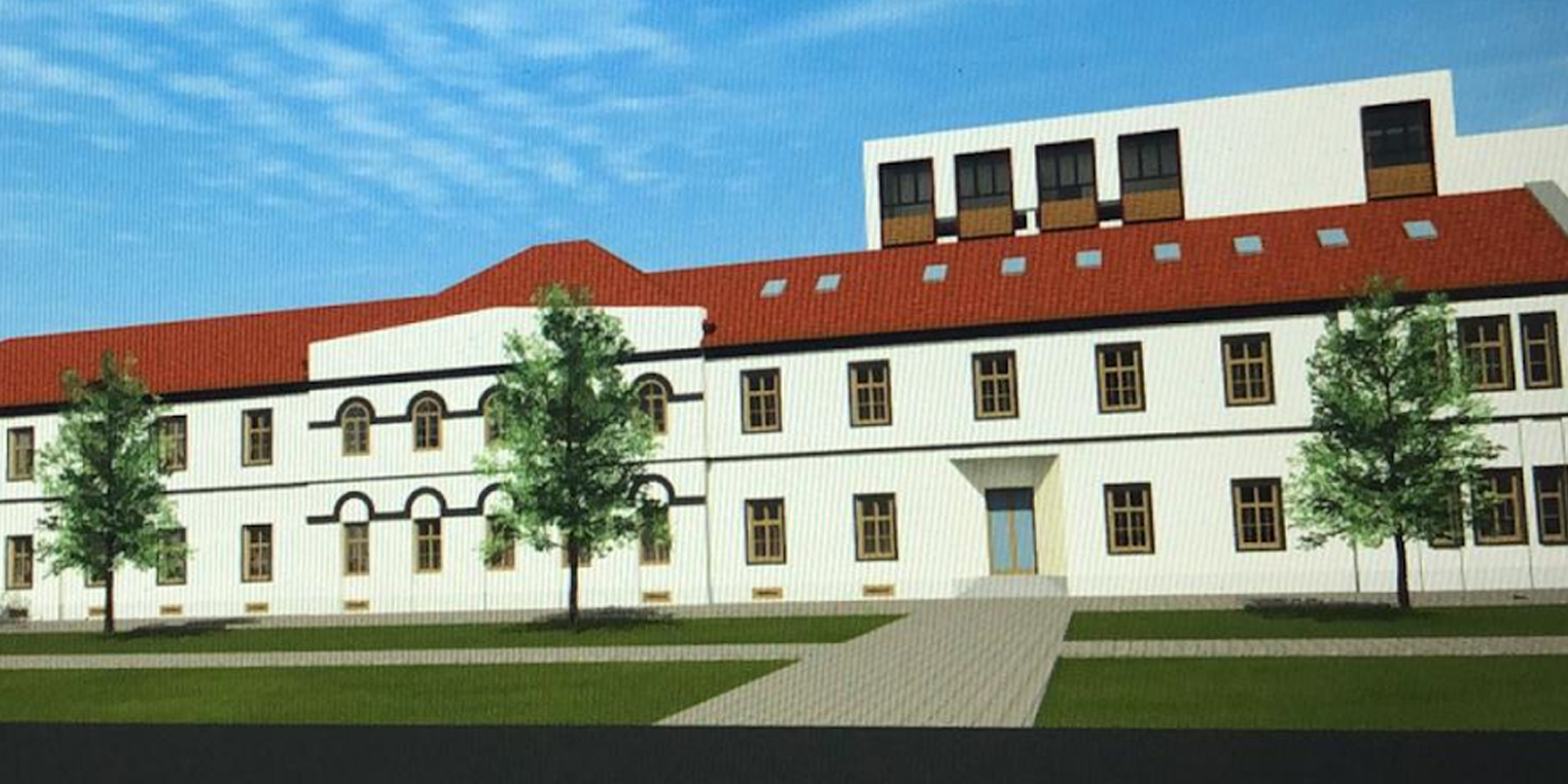
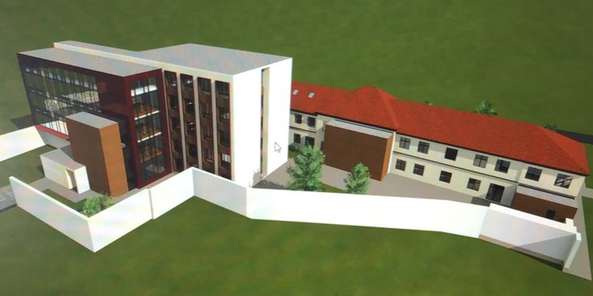
Figure 3.3a and b: Rehabilitation, modernization and endowment of the Technological Highschool from Jimbolia
Retrieved from Jimbolia Municipality
A question thus emerges: is Jimbolia’s orderly colonial structure still proving to be a viable model for present day spatial needs? Arguably, as we shall see, the answer is yes, granted that the resilience of its spatial patterns is correctly understood and further enhanced, according to their initial logic.
250 years later, Jimbolia’s highly efficient functional space – its 18th century source code – can still be repurposed and rewritten, if certain coding rules are followed. These rules must take into consideration:
-
- the physical form of the settlement, defined by the characteristics of the grid;
- the relation between the settlement and the larger context (both natural, as well as agricultural land);
- the areas of commons;
- the density and scale of the urban tissue;
- the atmosphere of the public space.
All these features amount to a local culture for space and urbanity that, at its core, has remained somewhat intact throughout three administration changes and their subsequent population / ethnic shifts.
While no longer part of an imperial economic project, Jimbolia is today slowly reattaching itself to the regional economic ecosystem, and – through the latter’s importance on a national level – to global economic chains and flows of capital. Old industries are gone, indeed, but new ones, mostly engaged in the manufacture of automotive components, have moved in. Their spatial position and logic is similar to that of old mills, brick, tiles or hat factories – namely on the immediate outskirts of Jimbolia, behind the ring of kaules (on the former area of commons).
Commuting between these objectives and Timișoara, the regional capital, is high, with seven trains moving in and out of the Jimbolia station daily. The settlement is similarly well connected to its hinterland villages and industrial facilities. It seems that this spatial preconditioning is, to a certain extent, a source for Jimbolia’s survival, and even economic relevance in the new spatial logic of Romania’s second most prosperous economic region, The Timiș County.
In this respect it is not an exception, but part of an already successful pre-existing rule, a consequence of the careful and efficient regional planning that was started in the 18th century.
From the point of view of the urban tissue, nowadays, the settlement sees two types of operations:
-
- the renaturalization of the former clay quarries in the north, as a consequence of the gradual abandonment and dismantling of former industrial facilities;
- the erection of new developments towards east and south, through the insertion of new manufacturing hotspots.
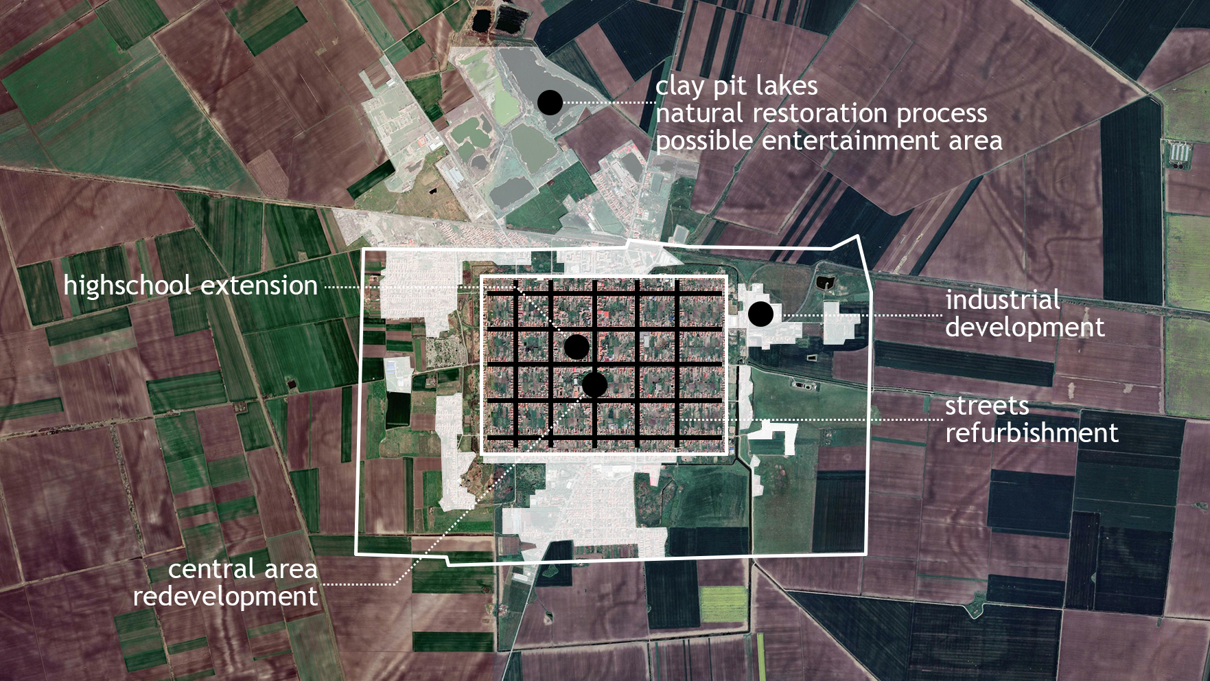
Figure 3.4: Main developments in and around present-day Jimbolia
Present day satellite view, retrieved from mapire.eu
Previous spatial patterns are thus repeated. The two large automotive manufacturers have built their production facilities using the pre-existing spatial resource, on the perimeter land, along the old canal, but this time in relation to the road towards Timișoara (the hotspot for all automotive industries in the region).
With the shift of almost all agricultural activities toward an industrial intensive format, this new type of colonization is not only taking advantage of this preordained spatial resource, but also of the preexisting proletarian working class.
Chapter 4. Land-use today – impact of major public infrastructure projects for territorial and economic resilience
Teaching method: workshop – utilizing specific instruments (a GIS-based application)
Duration: 135 min
The final chapter of this class develops the ability of students to assess the impact of a project in a limited territory, based on the various hypothetical scenarios introduced previously.
For small towns such as Jimbolia, lacking the financial capacity to self-manage and evolve sustainably, the possibility of applying for external funding sources is an exceptional opportunity. However, limited administrative and technical capacity makes it difficult to ensure that these funds are spent effectively to preserve local specificity and identity. From this point of view, the lack of an office dedicated to local heritage issues, as well as the lack of planning skills for a region with a high number of heritage objectives, are difficulties that need to be overcome.
A useful tool from this point of view is the KDK (Kommunale Denkmalkonzept) implemented in the Western Romania Region by the Agency for Regional Development in order to increase the quality of the built heritage objectives that are being restored or repurposed through European funds and Regional Operational Programs.
This tool makes it possible to identify and digitize the elements that create the specificity of spatial entities, from isolated elements of architecture to a broader urban context, with the involvement of the local community and specialists in the region. Usually addressed to small and medium-sized towns, this tool introduces a concept for urban renewal and redevelopment fostering community responsibility. Not only through planning means, but also through the empowerment of local stakeholders, the KDK heritage concept implements an instrument for the conservation, protection and development of heritage ensembles, introducing the inventory of relevant historical buildings.
Thus, the tool becomes a preservation plan for objects, ensembles and entire small scale municipalities, on the basis of three stages: recording, planning and implementation. Each step provides relevant information and is decisive in order to support the following one. Not just a planning concept, the instrument integrates formal and informal groups in the process, creating an environment in which local values expressed in heritage buildings are the most important theme.
Taking into consideration the facts mentioned above, the workshop introduces the fundamental characteristics for Jimbolia’s heritage, from territorial to architectural scale, as well as the brief input necessary for the new projects in order for them to have a positive impact on the built environment. For this purpose, GIS-type analysis and representation tools are used to visualize and analyze the specific situation, in three hypotheses:
-
- an architectural project in relation to a heritage object;
- an architectural object freely placed in the urban structure;
- a landscaping project or public space.
For each one of these, the workshop illustrates the key features that should govern the intervention, followed by the analysis of proposals identified in various sources and highlighting areas for improvement to generate spatially coherent urban structures, in an organic continuity with the already existing built environment and contributing to local socio-economic resilience.
[1] In this respect, see also Broadberry, S; Wallis, J. (2017). Growing, shrinking, and long-run economic performance

[2] In this respect, see also Echave, C. (2022). Territorial resilience: pillars for a holistic approach of resilience for land use planning

[3] In this respect, see also Sanchez-Zamora, P.; Gallardo-Cobos, R.; Cena Delgado, F. The Notion of Resilience in the Analysis of the Rural Territorial Dynamics: An Approach to the Concept through a Territorial Approach, in CUADERNOS DE DESARROLLO RURAL
[4] The performance of a territory is determined by its ability to respond to challenges, such as climate changes, demographic variations or economic requirements. In this respect, see also TPM - Territorial Performance Monitoring, a tool developed by ESPON in order to evaluate the way the territorial response towards these stimuli affects the regional realities
[5] In this respect, see also Radoslav, R.; Bădescu, Ș.; Branea, A.M.; Danciu, M. & Găman, M.S. (2012). Sistemul urban Timișoara în epoca modernă, in Urbanismul Serie nouă, Nr. 12-13
[6] In this respect, see also Radoslav R., Bădescu, S., Danciu, M.I. (2014). Evoluția parcelării în relație cu extinderea aglomerării urbane Timișoara, in Urbanismul Serie nouă, Nr. 16-17

[7] In this respect, see also Radoslav, R.; Bădescu, Ș.; Branea, A.M.; Danciu, M. & Găman, M.S. (2012). Sistemul urban Timișoara în epoca modernă, in Urbanismul Serie nouă, Nr. 12-13
References
-
- Echave, C. (2022). Territorial resilience: pillars for a holistic approach of resilience for land use planning, available at: https://www.euneighbours.eu/sites/default/files/publications/2022-04/EMEA_PP_Territorial_Resilience.pdf
- Gheorghiu, T.O. (2011). Sistematizarea Rurală în Banatul Secolelor XVIII-XIX, in Urbanismul. Serie Nouă, Nr. 7-8
- Sanchez-Zamora, P.; Gallardo-Cobos, R.; Cena Delgado, F. The Notion of Resilience in the Analysis of the Rural Territorial Dynamics: An Approach to the Concept through a Territorial Approach, in CUADERNOS DE DESARROLLO RURAL, available at: https://www.webofscience.com/wos/woscc/full-record/WOS:000384838300004
- Broadberry, S; Wallis, J. (2017). Growing, shrinking, and long-run economic performance, on www.voxeu.org, available at: https://voxeu.org/article/growing-shrinking-and-long-run-economic-performance
- Kommunales Denkmalkonzept Bayern KDK (2017), available at: https://www.denkmalnetzbayern.de/index.php/menueeintrag/index/id/17/seite_id/2003
- Sandmeier, J; Selitz, L.M. Das Kommunale Denkmalkonzept Bayern, in Städtebauliche Denkmalpflege als integrierte Praxis, available at https://link.springer.com/chapter/10.1007/978-3-658-30231-3_7
- Gheorghiu, T.O. (2019). The rural habitat and the Habsburg administration, in Neumann, V. The Banat of Timișoara: A European Melting Pot. London: Scala Arts Publishers Inc.
- Radoslav R., Bădescu, S., Danciu, M.I. (2014). Evoluția parcelării în relație cu extinderea aglomerării urbane Timișoara, in Urbanismul Serie nouă, Nr. 16-17
- Radoslav, R.; Bădescu, Ș.; Branea, A.M.; Danciu, M. & Găman, M.S. (2012). Sistemul urban Timișoara în epoca modernă, in Urbanismul Serie nouă, Nr. 12-13
Other Instructors

Ioan ANDREESCU
Professor

Cristian BLIDARIU
Associate Professor

Oana SIMIONESCU
Teaching Assistant

Ana BRANEA
Associate Professor

Mihai DANCIU
Teaching Assistant

Bogdan DEMETRESCU
Associate Professor
Bogdan ISOPESCU
Teaching Assistant

Ștefana BĂDESCU
Assistant Lecturer

Dan Răzvan DINU
Assistant Lecturer
Syllabus
The aim of this class is to facilitate the objective understanding of a territory, through the analysis of the physical components that determine its structure. In the case of colonial settlements, these refer to the grid - the urban pattern which allows settlers to create easily expandable structures that can grow in any direction and occupy the land following a clear set of rules. The third course of this class therefore concentrates on debating whether the strict confines of the grid and the urban structures that it generates can maintain their relevance under the unprecedently strong economic pressures of the present-day context. Having thrived and continuously adapted throughout centuries, some colonial settlements find it difficult to accommodate the economical growth, while also maintaining the strict urban rules.
O1.M1 UNDERSTANDING THE TERRITORY AS A SYSTEM
O1.M1.04 Reinventing the grid: the thin line between relevance and oblivion - Case study: Jimbolia in the new economic context
Type of format
Lecture & Workshop
Duration
90 min lecture (theoretical notions) 15 min break 135 min workshop (case study)
Possible connections (with other schools / presented topics)
UAUIM O1. M1.01 Grids, Formal tools for understanding and manipulating space O1. M1.05 Borders- theoretical research framework SUSKO O1. M2.02 Introduction to GIS story maps UBB O1. M2 01. Tools for visualizing the urban geography of economic growth KDK
Main purpose & objectives
The main purpose of this class is to help students understand and recognize the various morphological features of colonial settlements, as well as the way in which these can evolve and adapt (as a result of the interaction between economy, transportation, health and human services, as well as land-use regulation). In addition, the class introduces objective methods by which students can understand the prospective evolution of a territory, helping them to acquire design skills in relation to a context that is stagnant, declining or increasing. Especially relevant for major infrastructure projects, single public objectives and repetitive ones (such as national / cross-border facilities and connections), this class offers the possibility of a realistic approach, adapted to the context and economic realities of a particular site. The third course of this class therefore concentrates on the following objectives: introducing students to the main effects of the design according to the scenarios of territorial increase, decrease or stagnation, related to the main challenge of achieving resilience analyzing the public infrastructure projects carried out in recent years or in progress, having applicability on a well-defined case study understanding the impact of project implementation and the effects produced depending on the different scenarios a territory may go through
Skills acquired
Theoretical knowledge of the challenges that settlements go through, as a result of the economic, political and social changes that occurred over time Understanding of the key features of public infrastructure projects and the impact they may have on territorial challenges Ability to assess the impact of a project in a limited territory, based on various hypothetical scenarios introduced in advance
Contents and teaching methods
1. Theoretical principles of territorial resilience and the main driving factors for growth, stagnation or shrinkage Teaching method: lecture - theoretical approach 2. Territories’ performance in history - a brief introduction to territorial performance in relation to various economic and political influences Teaching method: lecture - exemplification, case study 3. The colonial city of Jimbolia: current situation Teaching method: lecture - exemplification, case study 4. Land-use today - impact of major public infrastructure projects for territorial and economic resilience Teaching method: workshop - utilizing specific instruments (a GIS-based application)
Reviews
Lorem Ipsn gravida nibh vel velit auctor aliquet. Aenean sollicitudin, lorem quis bibendum auci elit consequat ipsutis sem nibh id elit. Duis sed odio sit amet nibh vulputate cursus a sit amet mauris. Morbi accumsan ipsum velit. Nam nec tellus a odio tincidunt auctor a ornare odio. Sed non mauris vitae erat consequat auctor eu in elit.
Members
Lorem Ipsn gravida nibh vel velit auctor aliquet. Aenean sollicitudin, lorem quis bibendum auci elit consequat ipsutis sem nibh id elit. Duis sed odio sit amet nibh vulputate cursus a sit amet mauris. Morbi accumsan ipsum velit. Nam nec tellus a odio tincidunt auctor a ornare odio. Sed non mauris vitae erat consequat auctor eu in elit.