WORKING WITH/ON THE CULTURAL LANDSCAPE
The Nature of Anthropogenic Impacts
(Definition: The term “cultural landscape” embraces a diversity of manifestations of the interaction between humankind and its natural environment. Cultural landscapes often reflect specific techniques of sustainable land-use, considering the characteristics and limits of the natural environment they are established in, and a specific spiritual relation to nature.)
The paper presents a selection of architectural projects. The projects are usually dealing with multilayered cultural landscapes. The relation between the architectural concept and its physical and intellectual environment is in the focus of the design. The layers of history, natural values, archaeology and the built environment or its scarcity influence the design process, the selected case studies are reflecting on this approach.
Our field of interests and the locations of our field research are linked by larger-scale interconnections, as we deal with richly layered cultural landscapes. Essentially, we differentiate between three types: the designed landscape, the organically evolved landscape, and the associative cultural landscape. The “designed landscape” is a landscape planned and designed deliberately by humans, such as historical gardens and the parks of palaces. There are two subtypes of “organically evolving landscapes”: “fossilized landscapes” and “continuously evolving landscapes”. The fossil or relic landscape is one in which an evolutionary process came to an end at some time in the past, either abruptly or over a period. Its significant distinguishing features are, however, still visible in material form. The continuing landscape is one which retains an active social role in contemporary society closely associated with the traditional way of life, and in which the evolutionary process is still in progress. The third main category is the “associative landscape” which is justifiable by virtue of the powerful religious, artistic or cultural associations of the natural element rather than material cultural Evidence, which may be insignificant or even absent. The concept primarily refers to symbolic landscapes which are connected to religious, art-related, and historical events and are mainly memorials, battlefields, abandoned mines, or locations of other historically significant events. The sacred landscapes mentioned above also belong to this category (Vasáros 2018).
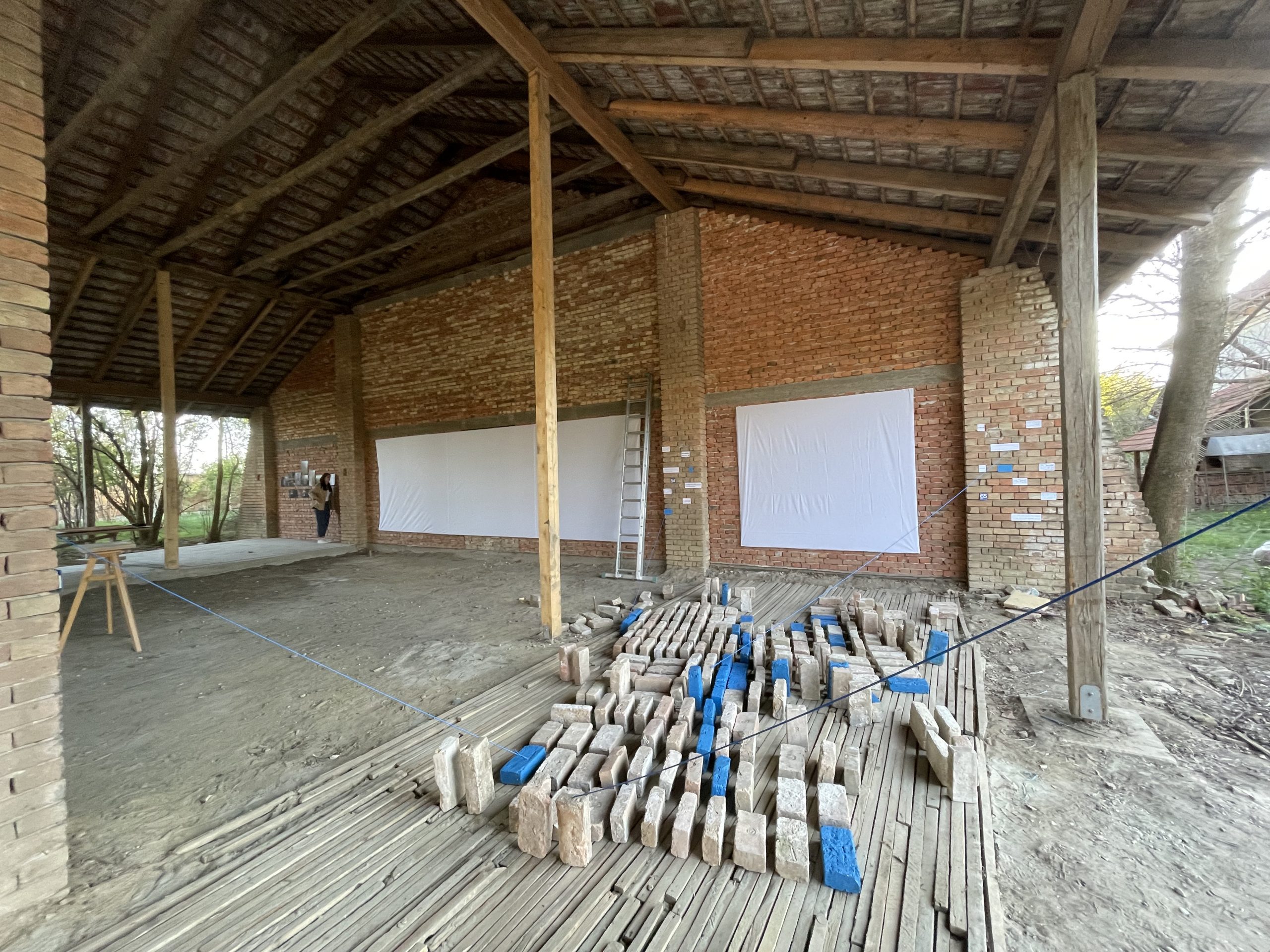
The idea for the topic came up in connection with the Triplex Confinium workshop and Summer School. Evidently the location of the fieldwork may also be interpreted as a multifaceted cultural landscape due to the history of Jimbolia over the course of the past century or so. The town built according to plan and its environment is clearly a designed landscape, which is made apparent by old maps and aerial photographs depicting the status today. Certain parts of the settlement have become fossilized, such as the territory of the former brick factory and mill, others have become relics, such, for example, the buildings of the Csitó Csekonics Castle and its elements distributed around the town. However, the larger part of the town remained and its development continued, and constitutes an excellent representative of the category of continuing landscape. In the course of the workshop and summer school we are searching for associative opportunities. The rich museum and local history collection, as well as our own observations have provided an excellent basis for this, however a different approach is required for the expression of these on the architectural scale and it is worthwhile becoming acquainted with the subject and some of its historical and contemporary representations.
Mortuary Landscape in Egypt
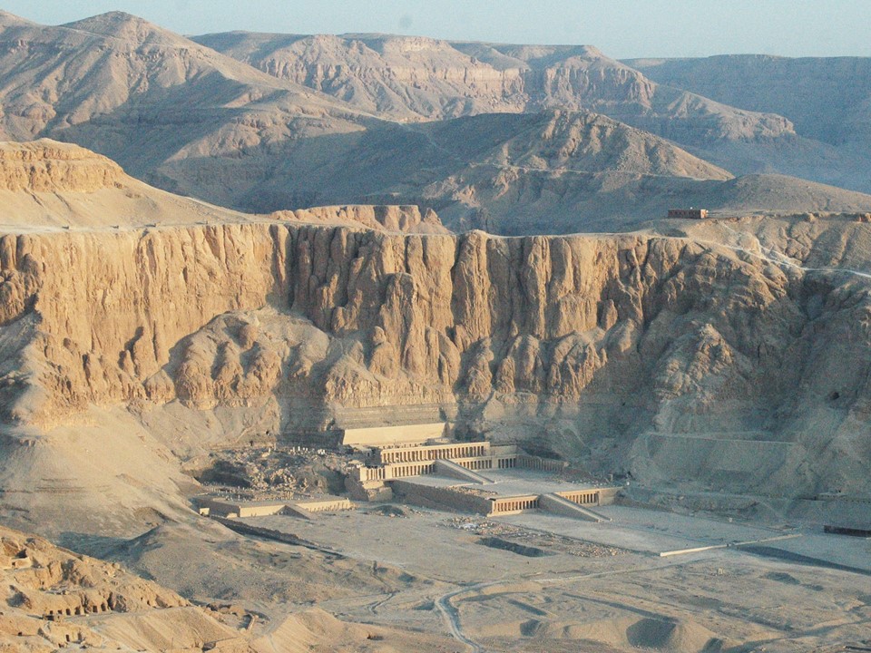
We introduce this subject in brief using a very obvious example. Notably with, perhaps, the world’s greatest designed landscape with its unparalleled richness, which holds a special position in the cultural history of humanity (Bradford 2020 and Iwaszczuk 2016). This is the Mortuary Landscape in Thebes, Egypt, the known, built history of which reaches back to the 3rd millennium BCE. These unique terrain-landscape features were used almost continuously throughout the three millennia of the Pharaonic Era. Mortuary temples, tombs, grand landscape-forming elements were built especially on the west bank as a part of the necropolis. These were constructed according to plans that were constantly updated in terms of their concept and architectural system of features, i.e., according to the prevailing “trend” of the age, or, more precisely, according to the ideas of the representation of the afterlife in this world. One may easily observe the progressivity as they used the characteristics of the landscape, notably the easily worked rock, carving it, building anew to create the built structures of the necropolis, with its world richly stratified in terms of space and time. This is what made the originally associative landscape into a designed landscape, and makes it today once again a site of associations for the tourists and, or course for the archaeologists and architects working on it.
(Photo 1: The Mortuary Landscape in Luxor West Bank: The Mortuary Temple of Queen Hatsepsut surrounded by tombs of the Nobleman, photo by Zsolt Vasáros, 2013.)
Dunafalva – Saving the Roman Fortlet
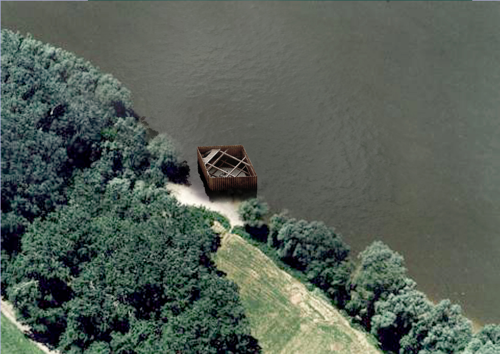
Close to Dunafalva the remains of a Late Roman fortlet may be observed for most of the year directly on the bank of the River Danube. The present circumstances of the ruins are due to the changes in the course of the riverbed, which in terms of volume represent just a very small detail of the former massive fortress. From our perspective this context represents a fossil or relic landscape. With respect to the special location, the architectural projection of this, or just merely saving the ruin, represented a particular technical and monument conservation task. Theoretically it is forbidden to build on the riverbed or floodplain due to the winter ice floes and the floods, exemptions to this are water management facilities and other necessary constructions, such as docks. Therefore, these constraints had to be taken into consideration in the architectural concept, in addition the ruin also had to be preserved as far as possible. The ruin, in its now uninterpretable, eroded form really is just a relic, the saving of which only has theoretical significance, nevertheless and good architectural response may even add value to the ruin. In the end the answer to the situation was implemented with a pronounced intervention using the tools of engineering. We proposed the use of steel panels conventionally used in riverbeds to create an exclusion that penetrates down to the impervious layers or aquicludes, thereby preventing the inward and upward ingress of water. The form follows the shape of structures that may be built in riverbeds. The wedge-shape does not obstruct the passage of the sheets of ice flowing down the river in very cold weather; therefore it does not represent a flood protection risk. The proposal still in the study design phase protects the relict, and uses engineering to initiate a new, progressive discourse with its environment, with the landscape, which, naturally, also permits novel associations.
(Photo 2: Study proposal of protecting construction. Design by Narmer Architecture Studio 2017.)
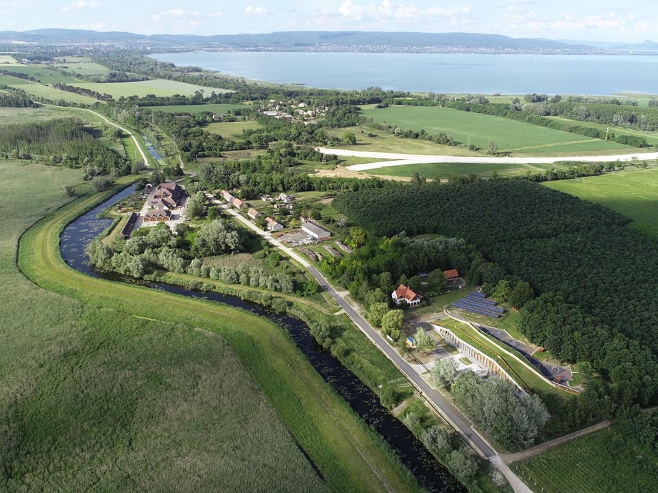
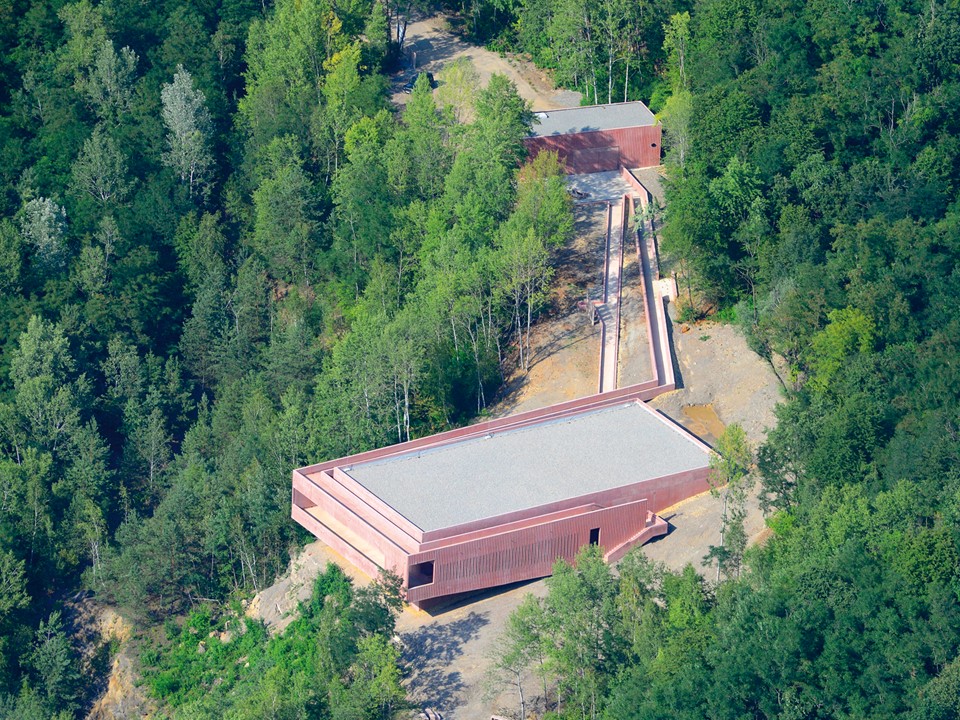
Keszthely/Fenékpuszta – The Kis-Balaton Visitor Centre Project
The visitor center designed for the Balaton Upland National Park was built in 2020 to accommodate the significant tourism demand. During the design process we devoted great attention to the concept. We examined the site, and assessed its main character elements. The Kis-Balaton, formerly acting as a natural filter for Lake Balaton was drained in the 1960s. The use of the area for agriculture did not live up to the expectations, and it also became essential to reconstruct the former wetland for the sake of the larger Lake Balaton. In this way we may talk of a dually designed landscape. First when the formerly marshy territory was terminated, and secondly when its restoration was attempted starting from the 1990s. The attributes of both landscape-scale interventions may be seen in the land, these being engineering facilities and landscape elements that determine the character of the location. With a view that we were designing a contemporary and modern function, it was obvious that our main architectural-conceptual guidelines should follow the character of this engineered landscape. Therefore we planned a facility on this designed landscape that resembled an engineering object, in this case a bridge, and endeavored to avoid the use of motifs characteristic of buildings of this type. In this way the building brings about a shape cut out from the surface with a number of motions and has a green roof that may be accessed. The rows of pronounced columns on the east and west sides associate with the vernacular porch, and in this way assist with the energy efficiency of the building, providing almost complete protection against direct sunlight. The associative character, essentially the events of today and the recent past, are reflected in the exterior, while in the interior the tourism functions, particularly the uncluttered character of the exhibition provides an abstract of the content of interest, the associations one actually experiences around the park.
(Photo 3: The Kis-Balaton Visitor Centre from above. Design: Narmer Architecture Studio 2014-2019, photo by Bendegúz Takáts, 2020.)
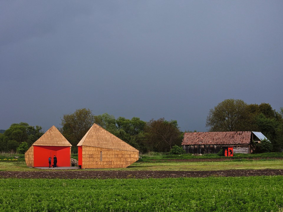
Felsőtelekes/Rudabánya – The Rudapithecus Project
The design area in the case of the Rudapithecus Visitor Centre and Site Museum was essentially a fossilized mining area. The fate of the quarry deserted in the 1980s and the potential lying within it represent a particularly special coincidence. All of the buildings of the iron ore quarry have been demolished and have disappeared, only the visible traces of the terraced mining and the quarry lake remind one of the former activities. All this, however, still remains a memorial to industrial history. Nature has reclaimed the area in a unique way with rich vegetation covering all the quarry terraces, which at one time had seemed infertile. The remains of the 8 to 10 million year old hominid discovered in the 1960s create a new cultural layer in the otherwise rich landscape that overwrites everything. Thus, when designing the presentation center we made use of an architectural language and approach system that, as far as possible, reflects upon each and every cultural layer, and that assists with their presentation and generates good associations. The pink-colored cast in situ concrete structures remind the visitor of industrial facilities with their character radiating timelessness. The color allows association with the soil, more precisely with the color of the iron ore lying within it. The abstract forms accommodate the geological time frame of the 8 to 10 million year old primate – we intentionally designed forms and architectural character that do not permit associations with any historical age, thereby no opportunity is given for incorrect interpretation or association (Vasáros 2016).
(Photo 4: The Rudapithecus Visitor Centre from above. Design: Narmer Architecture Studio and the Doctoral School of Architetcure at BME Budapest, 2011-2015, photo by János László-CIVERTAN, 2016.)
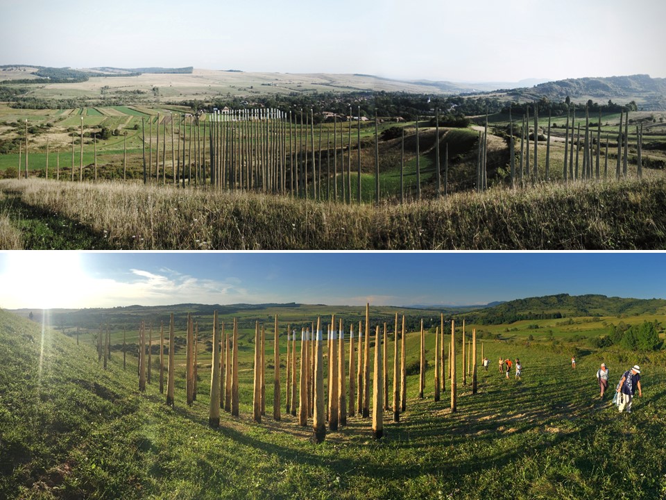
Călugăreni – The Roman Limes as European Cultural Landscape
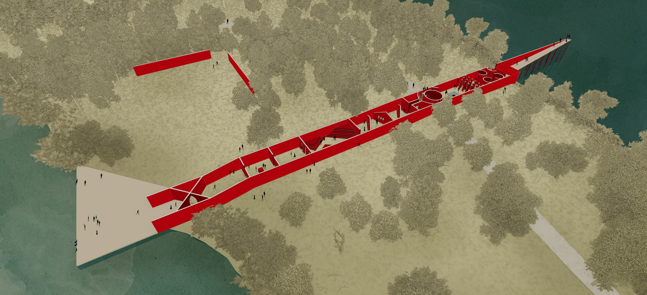
Naturally we can talk of fossil landscapes in the case of Călugăreni, if we think of the houses in the village that have remained but that are no longer occupied. From the aspect of our project carried out there (Roman Limes as European Cultural Landscape) we instead may talk of an associative landscape, as primarily we are searching for a way to recall the former Roman world and present its individual elements. With respect to this, in addition to the observations and the theoretical considerations, concrete interventions have also taken place (Vasáros-Sági 2020). The two information pavilions were constructed in 2015 (designed by Gergely Sági), the design and function of which are obviously contemporary. Their use of materials and architectural attitude, character recalls the elements characteristic of the village and region. It is the disappeared world of Rome that now appears in their functional essence and in terms of the exhibitions realized in them, as well as in their positioning. Thus, we are associating with the material used traditionally in the Roman Age, at the original location at the beginning of the 21st century. A viewpoint was built in 2018 also based on the designs of students of architecture (designed by Vera Lőcsei and Máté Ruga); here a composition of wooden poles demonstrates the position from where visitors obtain an exciting view of the excavation site. A stylized map of the Roman Empire may be seen on a concrete slab, with our location indicated on it. By standing there and viewing the valley from there the white painted tops of the poles mark out the position of the former fort – the white pole tops combine into a clear patch when viewed from the given point. In addition to the two successful, small-scale interventions, further landscape architecture and concrete architectural-monument presentations are planned; the professional justification of all this is assisted by the extensive excavations and the scientific processing.
(Photo 5: The information pavilions in Călugăreni. Design: Gergely Sági, 2013-2015, photo by Zsolt Vasáros, 2016.)
(Photo 6: The Lookout in Călugăreni – plan and the realized object. Design: Vera Lőcsei and Máté Ruga, 2014-2016, photo by Zsolt Vasáros, 2017.)
In connection with the historical and contemporary examples presented, it would have been an impossible undertaking to present a comprehensive picture of the subject in this dimension. The subject has an extensive literature, especially the world of cultural landscapes, for which there are numerous definitions and categorizations (Rubenstein 2016, Wallach 2005 and Cohen 2010) Beyond the importance of all this, the fact remains that there is hardly any territory on the Earth where man has had no impact, left no visible, or palpable or merely suggested trace. Multiple disciplines support the revealing of the traces of human impact on a given area, such as the ever-widening world of archaeology, aerial exploration and geophysical testing. The visible-palpable range is of particular importance to us architects, as this is how we obtain our first impressions, gather the experiences that serve as the base for our ideas and designs. The richness of the sensory input, the stratification of our ability to associate will determine the value of our architectural and landscape architecture concept, and its impact on the existing context. In other words, it comprises an important criterion of our architectural attitude, whether we understand the environment, the context where we design, that we shape with our design.
Text: Zsolt Vasáros
References
Bradford 2020 https://storymaps.arcgis.com/stories/66580880d1ee448ebc5691be52c88aa3
Cohen 2010 Cohen, M 2010, Changing Cultural Landscapes : How are people and their communities affected, New York.
Iwaszczuk 2016 Iwaszczuk, J 2016, Sacred Landscape of Thebes During the Reign of Hatshepsut: Royal Construction Projects. Topography of the West Bank (1).
Rubenstein 2016 Rubenstein, JM 2016, The Cultural Landscape: An Introduction to Human Geography, New York.
Vasáros 2016 Vasáros, Zs 2016, Rudapithecus Now! Synergie of Cultural, Natural and Industrial heritage. In: Bassa, L – Kiss, F (eds.), Proceedings of the TCL2016 Conference. Tourism and Cultural Landscapes: Towards A Sustainable Approach, 12-16 June, 2016 Budapest, Hungary, INFOTA, 599-411.
Vasáros 2018 Vasáros, Zs 2018, Kultúrtájról-kultúrtájra/A journey about cultural landscapes. In: DÁVID D. – TERBE R. –VASÁROS Zs. (szerk.) 2018a. identitás és kultúra 4/identity and culture 4. Ipartanszék füzetek No.5. Budapest, 8-11.
Vasáros-Sági 2020 Vasáros, Zs-Sági, G 2020, MIKHÁZA ÉPÍTÉSZETI ATLASZA/ARCHITECTURAL ATLAS OF CĂLUGĂRENI. Megfigyelés, felmérés, dokumentálás, tervezés és építés 2013-2019/Observation, survey, documentation, design & building 2013-2019. Budapest.
Wallach 2005 Wallach, B 2005, Understanding the Cultural Landscape, New York.